
Make a donation
Gear up for your next adventure:
As an Amazon Associate, this site earns from qualifying purchases at no extra cost to you.
Spring Brook Township topographic map
Click on the map to display elevation.
Make a donation
Gear up for your next adventure:
As an Amazon Associate, this site earns from qualifying purchases at no extra cost to you.
About this map
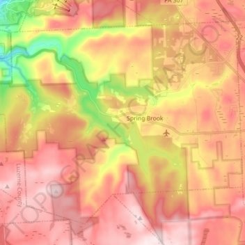
Name: Spring Brook Township topographic map, elevation, terrain.
Average elevation: 1,667 ft
Minimum elevation: 869 ft
Maximum elevation: 2,178 ft
Lackawanna County trails, hiking, mountain biking, running and outdoor activities
Make a donation
Gear up for your next adventure:
As an Amazon Associate, this site earns from qualifying purchases at no extra cost to you.
Other topographic maps
Click on a map to view its topography, its elevation and its terrain.
Mount Cobb
United States > Pennsylvania > Lackawanna County > Jefferson Township
Average elevation: 1,736 ft
Wimmers
United States > Pennsylvania > Lackawanna County > Jefferson Township > Mount Cobb
Average elevation: 1,624 ft
Make a donation
Gear up for your next adventure:
As an Amazon Associate, this site earns from qualifying purchases at no extra cost to you.
Pine Hill Vista
United States > Pennsylvania > Lackawanna County > Thornhurst Township
Average elevation: 2,060 ft
Make a donation
Gear up for your next adventure:
As an Amazon Associate, this site earns from qualifying purchases at no extra cost to you.
Birchwood Estates
United States > Pennsylvania > Lackawanna County > Roaring Brook Township
Average elevation: 1,680 ft
Falling Springs Reservoir
United States > Pennsylvania > Lackawanna County > Ransom Township
Average elevation: 1,230 ft
Madisonville
United States > Pennsylvania > Lackawanna County > Madison Township
Average elevation: 1,680 ft
Make a donation
Gear up for your next adventure:
As an Amazon Associate, this site earns from qualifying purchases at no extra cost to you.
Mount Cobb
United States > Pennsylvania > Lackawanna County > Jefferson Township
Average elevation: 1,736 ft
Make a donation
Gear up for your next adventure:
As an Amazon Associate, this site earns from qualifying purchases at no extra cost to you.
Elmhurst
United States > Pennsylvania > Lackawanna County > Elmhurst Township
Average elevation: 1,568 ft
Spring Brook
United States > Pennsylvania > Lackawanna County > Spring Brook Township
Average elevation: 1,519 ft
Montage Mountain
United States > Pennsylvania > Lackawanna County > Scranton
Average elevation: 1,585 ft
Make a donation
Gear up for your next adventure:
As an Amazon Associate, this site earns from qualifying purchases at no extra cost to you.
Waverly
United States > Pennsylvania > Lackawanna County > Waverly Township
Average elevation: 1,230 ft
Eagle Lake
United States > Pennsylvania > Lackawanna County > Covington Township
Average elevation: 1,896 ft
Make a donation
Gear up for your next adventure:
As an Amazon Associate, this site earns from qualifying purchases at no extra cost to you.