
Packington topographic map
Interactive map
Click on the map to display elevation.
About this map
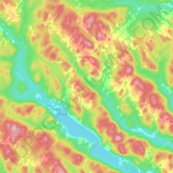
Name: Packington topographic map, elevation, terrain.
Location: Packington, Témiscouata, Bas-Saint-Laurent, Quebec, Canada (47.40377 -68.91196 47.53104 -68.71056)
Average elevation: 1,020 ft
Minimum elevation: 663 ft
Maximum elevation: 1,486 ft
Other topographic maps
Click on a map to view its topography, its elevation and its terrain.
Pohénégamook
Canada > Quebec > Témiscouata
Pohénégamook, Témiscouata, Bas-Saint-Laurent, Quebec, G0L 1J0, Canada
Average elevation: 1,253 ft