
Thank you for supporting this site ❤️
Make a donation
Make a donation
Gear up for your next adventure:
As an Amazon Associate, this site earns from qualifying purchases at no extra cost to you.
Woodmoor topographic map
Click on the map to display elevation.
Thank you for supporting this site ❤️
Make a donation
Make a donation
Gear up for your next adventure:
As an Amazon Associate, this site earns from qualifying purchases at no extra cost to you.
About this map
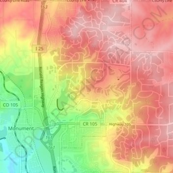
Name: Woodmoor topographic map, elevation, terrain.
Location: Woodmoor, El Paso County, Colorado, 80132, United States (39.07834 -104.86579 39.12989 -104.82251)
Average elevation: 7,251 ft
Minimum elevation: 6,860 ft
Maximum elevation: 7,513 ft
El Paso County trails, hiking, mountain biking, running and outdoor activities
Thank you for supporting this site ❤️
Make a donation
Make a donation
Gear up for your next adventure:
As an Amazon Associate, this site earns from qualifying purchases at no extra cost to you.