
Make a donation
Gear up for your next adventure:
As an Amazon Associate, this site earns from qualifying purchases at no extra cost to you.
Windigo Lake topographic map
Click on the map to display elevation.
Make a donation
Gear up for your next adventure:
As an Amazon Associate, this site earns from qualifying purchases at no extra cost to you.
About this map
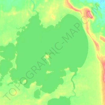
Name: Windigo Lake topographic map, elevation, terrain.
Average elevation: 1,135 ft
Minimum elevation: 1,043 ft
Maximum elevation: 1,325 ft
Make a donation
Gear up for your next adventure:
As an Amazon Associate, this site earns from qualifying purchases at no extra cost to you.
Other topographic maps
Click on a map to view its topography, its elevation and its terrain.
Wolf Island
Canada > Ontario > Kenora District > Unorganized Kenora District
Average elevation: 1,073 ft
Kakagi Lake
Canada > Ontario > Kenora District > Unorganized Kenora District
Average elevation: 1,207 ft
Slate Islands
Canada > Ontario > Kenora District > Unorganized Kenora District
Average elevation: 1,056 ft
Make a donation
Gear up for your next adventure:
As an Amazon Associate, this site earns from qualifying purchases at no extra cost to you.
Windermere Lake
Canada > Ontario > Kenora District > Unorganized Kenora District
Average elevation: 1,385 ft
Edison Lake
Canada > Ontario > Kenora District > Unorganized Kenora District
Average elevation: 1,263 ft
Redbluff Creek;Redbluff Lake
Canada > Ontario > Kenora District > Unorganized Kenora District
Average elevation: 1,247 ft