
Make a donation
Gear up for your next adventure:
As an Amazon Associate, this site earns from qualifying purchases at no extra cost to you.
Wejherowo topographic map
Click on the map to display elevation.
Make a donation
Gear up for your next adventure:
As an Amazon Associate, this site earns from qualifying purchases at no extra cost to you.
Wejherowo
Wejherowo is located in Pomeralia, in the ethnocultural region of Kashubia, approximately 11 km (7 mi) west of the town of Rumia, 32 kilometres (20 miles) east of the town of Lębork and 35 km (22 mi) north-west of the regional metropole of Gdańsk, in the broad glacial valley of the river Rheda at an altitude of 30 metres (98 feet) above sea level.
Make a donation
Gear up for your next adventure:
As an Amazon Associate, this site earns from qualifying purchases at no extra cost to you.
About this map
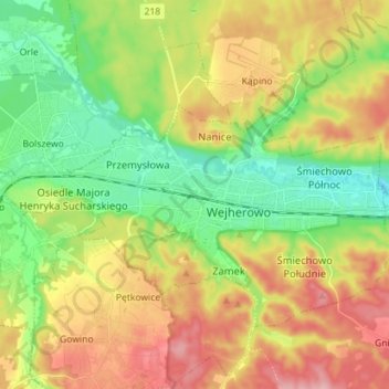
Name: Wejherowo topographic map, elevation, terrain.
Average elevation: 233 ft
Minimum elevation: 16 ft
Maximum elevation: 518 ft
Make a donation
Gear up for your next adventure:
As an Amazon Associate, this site earns from qualifying purchases at no extra cost to you.