Geolocate

Knottsville topographic map

Click on the map to display elevation.

About this map

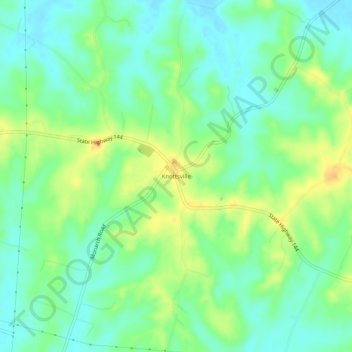
Name: Knottsville topographic map, elevation, terrain.

Location: Knottsville, Daviess County, Kentucky, United States (37.75172 -86.92416 37.79172 -86.88416)

Average elevation: 489 ft

Minimum elevation: 423 ft

Maximum elevation: 614 ft

Daviess County trails, hiking, mountain biking, running and outdoor activities

Other topographic maps

Click on a map to view its topography, its elevation and its terrain.

Owensboro

United States > Kentucky > Daviess County

Average elevation: 404 ft

Owensboro

United States > Kentucky > Daviess County

Average elevation: 404 ft

Owensboro

United States > Kentucky > Daviess County

Average elevation: 404 ft

Gear up for your next adventure:

🗺️Topographic Maps - Detailed topo maps for hiking, exploring and outdoor navigation
🔊Portable Camp Speaker - Music and alerts at camp
🛡️Bear Spray Outdoor - Protection in bear country hikes
🔦Powerful Headlamps - Ultra-bright hands-free lighting for night navigation
🧥Waterproof Jacket for Hiking - Breathable and rugged rain jacket for outdoor excursions

As an Amazon Associate, this site earns from qualifying purchases at no extra cost to you.