
Make a donation
Gear up for your next adventure:
As an Amazon Associate, this site earns from qualifying purchases at no extra cost to you.
Shreveport topographic map
Click on the map to display elevation.
Make a donation
Gear up for your next adventure:
As an Amazon Associate, this site earns from qualifying purchases at no extra cost to you.
Shreveport
Shreveport is the parish seat of Caddo Parish. Portions of the city extend into neighboring Bossier Parish, bordering Bossier City. Shreveport sits on a low elevation overlooking the Red River. Western and northern portions of Shreveport have an elevation over 253 feet (77 m) above sea level. Pine forests, cotton fields, wetlands, and waterways mark the outskirts of the city. According to the United States Census Bureau in 2010, the city had a total area of 122.35 sq mi (316.88 km2), of which 107.14 sq mi (277.48 km2) is land and 15.21 sq mi (39.40 km2) is water.
Make a donation
Gear up for your next adventure:
As an Amazon Associate, this site earns from qualifying purchases at no extra cost to you.
About this map
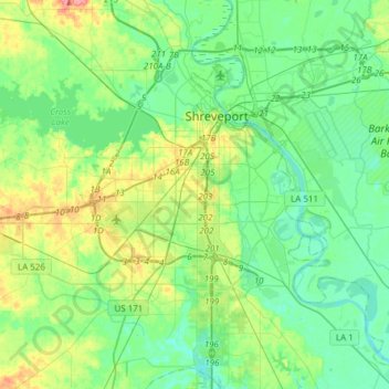
Name: Shreveport topographic map, elevation, terrain.
Location: Shreveport, Caddo Parish, Louisiana, United States (32.33269 -93.94785 32.58987 -93.67972)
Average elevation: 190 ft
Minimum elevation: 125 ft
Maximum elevation: 367 ft
Caddo Parish trails, hiking, mountain biking, running and outdoor activities
Make a donation
Gear up for your next adventure:
As an Amazon Associate, this site earns from qualifying purchases at no extra cost to you.
Other topographic maps
Click on a map to view its topography, its elevation and its terrain.
Make a donation
Gear up for your next adventure:
As an Amazon Associate, this site earns from qualifying purchases at no extra cost to you.
Make a donation
Gear up for your next adventure:
As an Amazon Associate, this site earns from qualifying purchases at no extra cost to you.
Cynthia Park
United States > Louisiana > Caddo Parish > Shreveport > Cynthia Park
Average elevation: 233 ft