Geolocate

Asaba topographic map

Click on the map to display elevation.

About this map

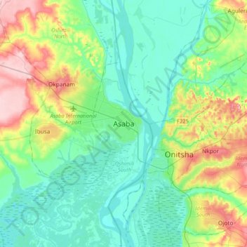
Name: Asaba topographic map, elevation, terrain.

Location: Asaba, Oshimili South, Delta State, Nigeria (6.02588 6.56971 6.34588 6.88971)

Average elevation: 203 ft

Minimum elevation: 33 ft

Maximum elevation: 679 ft

Gear up for your next adventure:

📶Satellite Messenger - Communication device off‑grid
🧣Hiking Neck Gaiter - Multi‑use neck protection for outdoor weather
🎁Geography Themed Gifts - Unique gift ideas for map lovers and geography enthusiasts
🔦Powerful Headlamps - Ultra-bright hands-free lighting for night navigation
Backpacking Tent - Lightweight and durable tent for multi‑day hikes

As an Amazon Associate, this site earns from qualifying purchases at no extra cost to you.