
Make a donation
Gear up for your next adventure:
As an Amazon Associate, this site earns from qualifying purchases at no extra cost to you.
Bad Saarow topographic map
Click on the map to display elevation.
Make a donation
Gear up for your next adventure:
As an Amazon Associate, this site earns from qualifying purchases at no extra cost to you.
Bad Saarow
Innerhalb der Feldmarken liegen die Wohnplätze Am Dudel, Annenhof, Bad Saarow-Mitte, Bad Saarow-Strand, Dorf Saarow, Fuchsbau, Marienhöhe und Theresienhof.
Make a donation
Gear up for your next adventure:
As an Amazon Associate, this site earns from qualifying purchases at no extra cost to you.
About this map
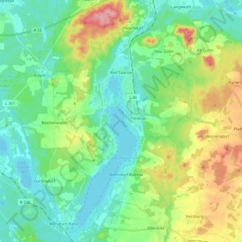
Name: Bad Saarow topographic map, elevation, terrain.
Average elevation: 223 ft
Minimum elevation: 112 ft
Maximum elevation: 486 ft
Make a donation
Gear up for your next adventure:
As an Amazon Associate, this site earns from qualifying purchases at no extra cost to you.
Other topographic maps
Click on a map to view its topography, its elevation and its terrain.
Großer Treppelsee
Deutschland > Brandenburg > Oder-Spree > Schlaubetal > Bremsdorf
Average elevation: 259 ft
Make a donation
Gear up for your next adventure:
As an Amazon Associate, this site earns from qualifying purchases at no extra cost to you.
Make a donation
Gear up for your next adventure:
As an Amazon Associate, this site earns from qualifying purchases at no extra cost to you.
Make a donation
Gear up for your next adventure:
As an Amazon Associate, this site earns from qualifying purchases at no extra cost to you.
Make a donation
Gear up for your next adventure:
As an Amazon Associate, this site earns from qualifying purchases at no extra cost to you.
Make a donation
Gear up for your next adventure:
As an Amazon Associate, this site earns from qualifying purchases at no extra cost to you.
Großer Storkower See
Deutschland > Brandenburg > Oder-Spree > Storkow (Mark)
Das 3,7 km² große Gewässer befindet sich innerhalb der Stadtgrenzen von Storkow (Mark). Es besteht aus dem nördlichen, kleineren und einem langgestreckten, südlichen Becken, die durch eine etwa 200 Meter breite Seeenge miteinander verbunden sind. Der Ort Storkow erstreckt sich am Nord- und Westufer, der…
Average elevation: 151 ft