Geolocate

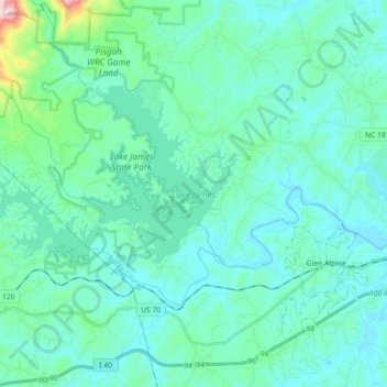
Lake James topographic map

Click on the map to display elevation.

Lake James

Lake James is a large reservoir in the mountains of Western North Carolina which straddles the border between Burke and McDowell Counties. It is named for tobacco tycoon and benefactor of Duke University James Buchanan Duke. The lake, with surface elevation of 1200 ft (366 m), lies behind a series of 4 earthen dams. It was created by Duke Power between 1916 and 1923 as a hydro-electric project. It still generates power today and is the uppermost lake on the Catawba River system.

Wikipedia (CC-BY-SA 3.0)

About this map

Name: Lake James topographic map, elevation, terrain.

Location: Lake James, Burke County, North Carolina, United States (35.71392 -81.99982 35.79624 -81.82004)

Average elevation: 1,250 ft

Minimum elevation: 1,020 ft

Maximum elevation: 2,785 ft

Burke County trails, hiking, mountain biking, running and outdoor activities

Other topographic maps

Click on a map to view its topography, its elevation and its terrain.
Wiseman's View

United States > North Carolina > Burke County

Average elevation: 2,913 ft

Jonas Ridge

United States > North Carolina > Burke County

Average elevation: 3,727 ft

Yellow Mountain

United States > North Carolina > Burke County

Average elevation: 1,427 ft

Parkhill

United States > North Carolina > Burke County

Average elevation: 1,207 ft

Jonas Ridge

United States > North Carolina > Burke County

Average elevation: 3,727 ft

Linville

United States > North Carolina > Burke County

Average elevation: 1,352 ft

Jonas Ridge

United States > North Carolina > Burke County

Average elevation: 3,727 ft

Gold

United States > North Carolina > Burke County

Average elevation: 1,211 ft

Cedar Mountain

United States > North Carolina > Burke County

Average elevation: 1,749 ft

Gear up for your next adventure:

🧦Hiking Socks - Comfortable socks to prevent blisters on long hikes
🔭Compact Binoculars - HD vision for scouting terrain and identifying distant landmarks
🔦LED Headlamp - Bright and durable LED headlamp for night navigation
🏫Relief Map Kits - Hands-on tools for teaching landforms and elevation
📡Handheld GPS Device - Reliable handheld GPS for outdoor navigation

As an Amazon Associate, this site earns from qualifying purchases at no extra cost to you.