Geolocate

Folignano topographic map

Click on the map to display elevation.

About this map
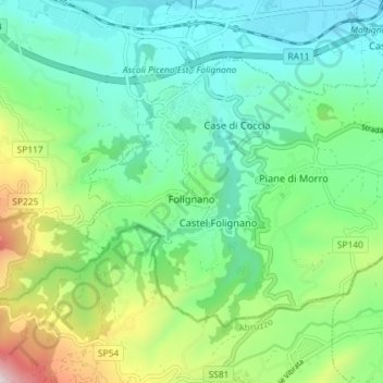
Name: Folignano topographic map, elevation, terrain.

Location: Folignano, Ascoli Piceno, Marche, 63084, Italy (42.80259 13.61458 42.83998 13.68670)

Average elevation: 1,017 ft

Minimum elevation: 217 ft

Maximum elevation: 3,140 ft

Other topographic maps

Click on a map to view its topography, its elevation and its terrain.

Favalanciata

Italy > Marche > Ascoli Piceno > Acquasanta Terme

Average elevation: 2,487 ft

Montemoro

Italy > Marche > Ascoli Piceno > Force

Average elevation: 2,001 ft

San Martino

Italy > Marche > Ascoli Piceno > Castignano

Average elevation: 1,276 ft

Magazzini

Italy > Marche > Ascoli Piceno > Ripatransone

Average elevation: 482 ft

Conca degli Ulivi

Italy > Marche > Ascoli Piceno > Acquaviva Picena

Average elevation: 479 ft

Ponte Tesino

Italy > Marche > Ascoli Piceno > Cossignano

Average elevation: 820 ft

Petrella

Italy > Marche > Ascoli Piceno > Ripatransone

Average elevation: 791 ft

Gear up for your next adventure:

🌡️Handheld Weather Meters - Measure wind, temp, and pressure for safe mountain travel
🦺Reflective Outdoor Gear - Safety gear for low‑light conditions
🎒Trekking Poles - Sturdy poles for balance and stability on rough terrain
📡Handheld GPS Device - Reliable handheld GPS for outdoor navigation
🔭Telescopic Hiking Pole - Adjustable pole for hiking stability

As an Amazon Associate, this site earns from qualifying purchases at no extra cost to you.