
King Lake topographic map
Click on the map to display elevation.
About this map
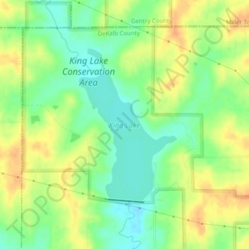
Name: King Lake topographic map, elevation, terrain.
Average elevation: 988 ft
Minimum elevation: 928 ft
Maximum elevation: 1,047 ft
DeKalb County trails, hiking, mountain biking, running and outdoor activities
Other topographic maps
Click on a map to view its topography, its elevation and its terrain.
Grindstone-Lost-Muddy Creek Watershed Dam A-39
United States > Missouri > DeKalb County
Average elevation: 978 ft