Make a donation
Gear up for your next adventure:
As an Amazon Associate, this site earns from qualifying purchases at no extra cost to you.
Almalyk topographic map
Click on the map to display elevation.
Make a donation
Gear up for your next adventure:
As an Amazon Associate, this site earns from qualifying purchases at no extra cost to you.
Almalyk
Olmaliq (Uzbek: Olmaliq / Олмалиқ, Russian: Алмалык, romanized: Almalyk) is a district-level city (2021 pop 133,400) in the Tashkent Region of central Uzbekistan, approximately 65 km east of Tashkent. It is located at latitude 40° 50' 41N; longitude 69° 35' 54E; at an altitude of 585 meters.
Make a donation
Gear up for your next adventure:
As an Amazon Associate, this site earns from qualifying purchases at no extra cost to you.
About this map
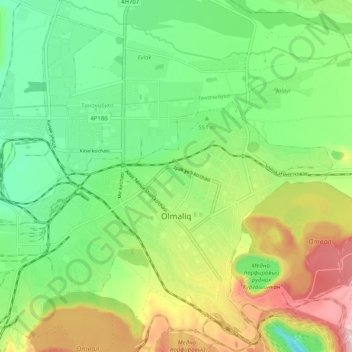
Name: Almalyk topographic map, elevation, terrain.
Location: Almalyk, Tashkent Region, Uzbekistan (40.81917 69.55076 40.88979 69.65257)
Average elevation: 1,873 ft
Minimum elevation: 1,447 ft
Maximum elevation: 2,615 ft
Make a donation
Gear up for your next adventure:
As an Amazon Associate, this site earns from qualifying purchases at no extra cost to you.
Other topographic maps
Click on a map to view its topography, its elevation and its terrain.
Make a donation
Gear up for your next adventure:
As an Amazon Associate, this site earns from qualifying purchases at no extra cost to you.
