
Make a donation
Gear up for your next adventure:
As an Amazon Associate, this site earns from qualifying purchases at no extra cost to you.
Narok topographic map
Click on the map to display elevation.
Make a donation
Gear up for your next adventure:
As an Amazon Associate, this site earns from qualifying purchases at no extra cost to you.
Narok
Narok (sometimes referred to as NauwongoTown) is a town west of Nairobi that supports Kenya's economy in south-west of the country, along the Great Rift Valley. Narok is the county capital of the Narok County and stands as the major centre of commerce in the county. Narok has a population of around 117, 607 people according to 2019 Census, mostly Maasai. The elevation of Narok is 1827 metres (5,997 feet) in altitude.
Make a donation
Gear up for your next adventure:
As an Amazon Associate, this site earns from qualifying purchases at no extra cost to you.
About this map
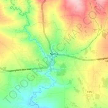
Name: Narok topographic map, elevation, terrain.
Location: Narok, Narok Town ward, Narok North, Narok, Kenya (-1.12869 35.83149 -1.04869 35.91149)
Average elevation: 6,299 ft
Minimum elevation: 5,978 ft
Maximum elevation: 6,709 ft
Make a donation
Gear up for your next adventure:
As an Amazon Associate, this site earns from qualifying purchases at no extra cost to you.