
Make a donation
Gear up for your next adventure:
As an Amazon Associate, this site earns from qualifying purchases at no extra cost to you.
Shadra topographic map
Click on the map to display elevation.
Make a donation
Gear up for your next adventure:
As an Amazon Associate, this site earns from qualifying purchases at no extra cost to you.
Shadra
The population is Greek Orthodox and other Christian. The village is situated at a distance of 146km from Beirut at an altitude of 450 m above sea level. It has an area of 651 hectares, surrounded by Akroum from the east, the west Owainat, from the north Machta Hassan and Andaket from the south . Can be accessed in two ways.
Make a donation
Gear up for your next adventure:
As an Amazon Associate, this site earns from qualifying purchases at no extra cost to you.
About this map
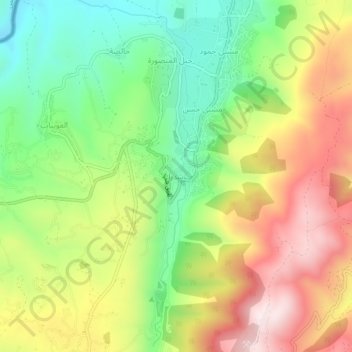
Name: Shadra topographic map, elevation, terrain.
Location: Shadra, Akkar District, Akkar Governorate, Lebanon (34.59887 36.30022 34.63887 36.34022)
Average elevation: 1,693 ft
Minimum elevation: 774 ft
Maximum elevation: 2,812 ft
Make a donation
Gear up for your next adventure:
As an Amazon Associate, this site earns from qualifying purchases at no extra cost to you.
Other topographic maps
Click on a map to view its topography, its elevation and its terrain.
Make a donation
Gear up for your next adventure:
As an Amazon Associate, this site earns from qualifying purchases at no extra cost to you.
Make a donation
Gear up for your next adventure:
As an Amazon Associate, this site earns from qualifying purchases at no extra cost to you.