
Danville topographic map
Click on the map to display elevation.
Danville
According to the United States Census Bureau, the town has a total area of 11.8 square miles (30.6 km2), of which 11.7 square miles (30.2 km2) are land and 0.2 square miles (0.5 km2) are water, comprising 1.53% of the town. The highest named summit in Danville is Rock Rimmon Hill, with an elevation greater than 350 feet (110 m) above sea level on the town's eastern border. An unnamed hill on the town's western border also tops 350 feet. The southern two-thirds of Danville lies within the Merrimack River watershed, and the northern third is in the Piscataqua River (Coastal) watershed.
About this map
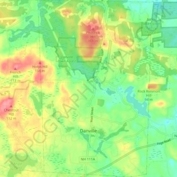
Name: Danville topographic map, elevation, terrain.
Average elevation: 217 ft
Minimum elevation: 102 ft
Maximum elevation: 371 ft
Rockingham County trails, hiking, mountain biking, running and outdoor activities
Other topographic maps
Click on a map to view its topography, its elevation and its terrain.
Hampton Beach
United States > New Hampshire > Rockingham County > Hampton Beach
Average elevation: 7 ft
Four Corners
United States > New Hampshire > Rockingham County > Newmarket > Four Corners
Average elevation: 92 ft
South Mount Pawtuckaway
United States > New Hampshire > Rockingham County > Nottingham
Average elevation: 469 ft
Dearborn Park
United States > New Hampshire > Rockingham County > North Hampton
Average elevation: 66 ft
Hampton Falls
United States > New Hampshire > Rockingham County > Hampton Falls
Average elevation: 49 ft
East Hampstead
United States > New Hampshire > Rockingham County > East Hampstead
Average elevation: 249 ft