
Make a donation
Gear up for your next adventure:
As an Amazon Associate, this site earns from qualifying purchases at no extra cost to you.
Cotoca topographic map
Click on the map to display elevation.
Make a donation
Gear up for your next adventure:
As an Amazon Associate, this site earns from qualifying purchases at no extra cost to you.
Cotoca
Se encuentra situada en la zona este de la provincia Andrés Ibáñez junto al río Grande, limitando al norte, al sur y al oeste con el municipio de Santa Cruz de la Sierra y al este con el municipio de Pailón de la provincia Chiquitos. Su topografía es completamente llana, con un clima cálido con temperaturas extremas de 9 °C en invierno y 35 °C en verano, con una media de 24 °C.
Make a donation
Gear up for your next adventure:
As an Amazon Associate, this site earns from qualifying purchases at no extra cost to you.
About this map
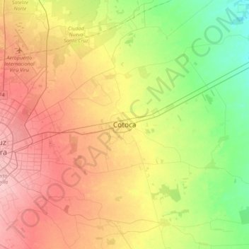
Name: Cotoca topographic map, elevation, terrain.
Average elevation: 1,161 ft
Minimum elevation: 971 ft
Maximum elevation: 1,375 ft
Make a donation
Gear up for your next adventure:
As an Amazon Associate, this site earns from qualifying purchases at no extra cost to you.
Other topographic maps
Click on a map to view its topography, its elevation and its terrain.
Municipio Porongo (Ayacucho)
Bolivia > Santa Cruz > Provincia Andrés Ibáñez
Average elevation: 1,539 ft