
Make a donation
Gear up for your next adventure:
As an Amazon Associate, this site earns from qualifying purchases at no extra cost to you.
Oberreifenberg topographic map
Click on the map to display elevation.
Make a donation
Gear up for your next adventure:
As an Amazon Associate, this site earns from qualifying purchases at no extra cost to you.
Oberreifenberg
Oberreifenberg im östlichen Hintertaunus ist mit durchschnittlich 640 Meter in der Ortslage das höchstgelegene Dorf im Taunus, und eines der höchstgelegenen Dörfer in Hessen. Es liegt auf einem nach Nordwesten gerichteten Ausläufer des rund 1,5 Kilometer entfernten und 879 Meter hohen Großen Feldbergs. Die Gemarkung des Ortes hat eine Fläche von 383 Hektar. Der höchstgelegene Punkt der Gemarkung findet sich im Südosten, wo die Gemarkungsgrenze im Walddistrikt Stölker auf 350 Meter Länge dem Obergermanisch-Raetischen Limes folgt. Hier, wo die vom Feldberggipfel herabführende Nordbahn-Piste den Limes quert, erreicht die Gemarkung eine Höhe von 770 m. Demgegenüber liegt im Norden der Gemarkung der tiefste Punkt im Weiltal am oberen Bärenfichtenweiher unterhalb der Reste der Burg Hattstein bei 460 m. Am östlichen Ortsrand erhebt sich über der Siegfriedsiedlung der Dillenberg, mit 682,4 m ü. NHN achthöchster Gipfel des Taunus.
Make a donation
Gear up for your next adventure:
As an Amazon Associate, this site earns from qualifying purchases at no extra cost to you.
About this map
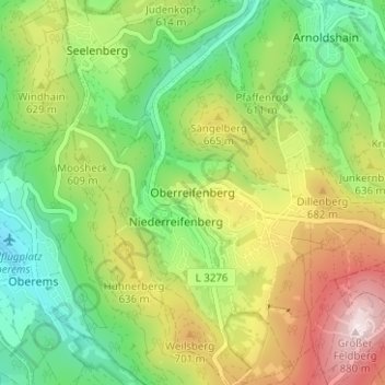
Name: Oberreifenberg topographic map, elevation, terrain.
Average elevation: 1,929 ft
Minimum elevation: 1,283 ft
Maximum elevation: 2,900 ft
Make a donation
Gear up for your next adventure:
As an Amazon Associate, this site earns from qualifying purchases at no extra cost to you.