
Thank you for supporting this site ❤️
Make a donation
Make a donation
Gear up for your next adventure:
As an Amazon Associate, this site earns from qualifying purchases at no extra cost to you.
Gwonseon-gu topographic map
Click on the map to display elevation.
Thank you for supporting this site ❤️
Make a donation
Make a donation
Gear up for your next adventure:
As an Amazon Associate, this site earns from qualifying purchases at no extra cost to you.
About this map
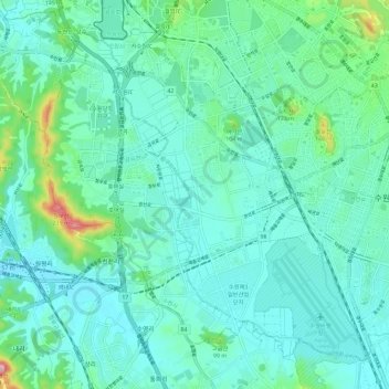
Name: Gwonseon-gu topographic map, elevation, terrain.
Location: Gwonseon-gu, Suwon-si, Gyeonggi, South Korea (37.22453 126.92697 37.30331 127.04216)
Average elevation: 154 ft
Minimum elevation: 26 ft
Maximum elevation: 778 ft
Thank you for supporting this site ❤️
Make a donation
Make a donation
Gear up for your next adventure:
As an Amazon Associate, this site earns from qualifying purchases at no extra cost to you.