
Thank you for supporting this site ❤️
Make a donation
Make a donation
Gear up for your next adventure:
As an Amazon Associate, this site earns from qualifying purchases at no extra cost to you.
Yumbo topographic map
Click on the map to display elevation.
Thank you for supporting this site ❤️
Make a donation
Make a donation
Gear up for your next adventure:
As an Amazon Associate, this site earns from qualifying purchases at no extra cost to you.
About this map
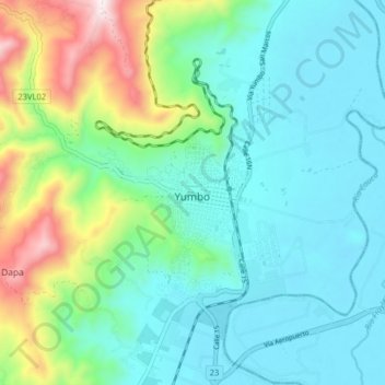
Name: Yumbo topographic map, elevation, terrain.
Location: Yumbo, Sur, Valle del Cauca, 032, Colombia (3.54347 -76.53522 3.62347 -76.45522)
Average elevation: 3,652 ft
Minimum elevation: 3,064 ft
Maximum elevation: 5,571 ft
Thank you for supporting this site ❤️
Make a donation
Make a donation
Gear up for your next adventure:
As an Amazon Associate, this site earns from qualifying purchases at no extra cost to you.