
St. Pölten topographic map
Click on the map to display elevation.
About this map
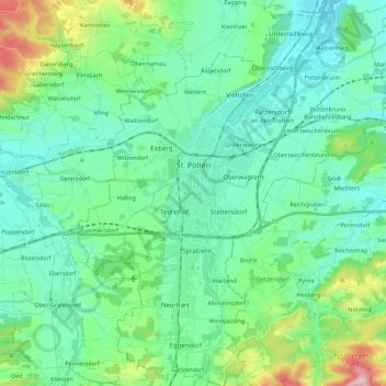
Name: St. Pölten topographic map, elevation, terrain.
Location: St. Pölten, Lower Austria, Austria (48.11848 15.55590 48.26830 15.73918)
Average elevation: 1,014 ft
Minimum elevation: 745 ft
Maximum elevation: 2,051 ft
Other topographic maps
Click on a map to view its topography, its elevation and its terrain.
Suttenbrunn
Austria > Lower Austria > Bezirk Hollabrunn > Gemeinde Hollabrunn
Average elevation: 846 ft
Joachimstal
Austria > Lower Austria > Bezirk Gmünd > Gemeinde Sankt Martin
Average elevation: 2,762 ft
Klosterwappen
Austria > Lower Austria > Bezirk Neunkirchen > Reichenau an der Rax
Average elevation: 5,627 ft
Kirchberg an der Pielach
Austria > Lower Austria > Bezirk St. Pölten > Gemeinde Kirchberg an der Pielach > Kirchberg an der Pielach
Average elevation: 1,575 ft
Klein-Wien
Austria > Lower Austria > Bezirk Krems > Gemeinde Furth bei Göttweig
Average elevation: 1,010 ft