Geolocate

Mezzacca topographic map

Click on the map to display elevation.

About this map

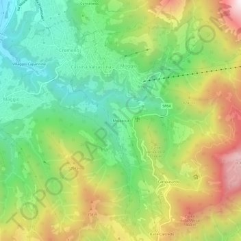
Name: Mezzacca topographic map, elevation, terrain.

Location: Mezzacca, Cassina Valsassina, Lecco, Lombardia, 23817, Italia (45.90315 9.46606 45.94315 9.50606)

Average elevation: 3,448 ft

Minimum elevation: 1,991 ft

Maximum elevation: 5,623 ft

Gear up for your next adventure:

Solar GPS Watches - Advanced multisport watches with built-in topographic maps
🕶️GPS Smartphone Mount - Secure mount for phone navigation
Backpacking Tent - Lightweight and durable tent for multi‑day hikes
🪵Folding Camp Saw - Compact saw for wood and campsite work
👟Trail Running Shoes - Lightweight shoes for trail runners

As an Amazon Associate, this site earns from qualifying purchases at no extra cost to you.