
Make a donation
Gear up for your next adventure:
As an Amazon Associate, this site earns from qualifying purchases at no extra cost to you.
Hinterstoder topographic map
Click on the map to display elevation.
Make a donation
Gear up for your next adventure:
As an Amazon Associate, this site earns from qualifying purchases at no extra cost to you.
Hinterstoder
Hinterstoder is a municipality in the district of Kirchdorf an der Krems, in the Austrian state of Upper Austria. The village lies on the southern edge of the district near the border with Styria, at an altitude of around 600 m. Surrounded by the limestone peaks of the Totes Gebirge range, including the Großer Priel (2,514 m) and the Spitzmauer (2,446 m), Hinterstoder has developed from a small alpine settlement into an internationally recognized ski resort.
Make a donation
Gear up for your next adventure:
As an Amazon Associate, this site earns from qualifying purchases at no extra cost to you.
About this map
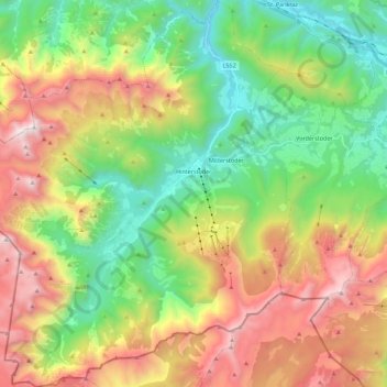
Name: Hinterstoder topographic map, elevation, terrain.
Location: Hinterstoder, Bezirk Kirchdorf, Upper Austria, 4573, Austria (47.61590 14.01060 47.76613 14.21258)
Average elevation: 4,209 ft
Minimum elevation: 1,591 ft
Maximum elevation: 8,205 ft
Make a donation
Gear up for your next adventure:
As an Amazon Associate, this site earns from qualifying purchases at no extra cost to you.
Other topographic maps
Click on a map to view its topography, its elevation and its terrain.