
Make a donation
Gear up for your next adventure:
As an Amazon Associate, this site earns from qualifying purchases at no extra cost to you.
Buffalo National River topographic map
Click on the map to display elevation.
Make a donation
Gear up for your next adventure:
As an Amazon Associate, this site earns from qualifying purchases at no extra cost to you.
Buffalo National River
Along the upper river, the gradient is steep and the water is fast, leveling and slowing as the river runs its course. The upper section has most of the whitewater rapids to be found along the river, and features dramatic karst topography including sink holes and caves, springs, and waterfalls, over 500-foot (150 m) tall sandstone and limestone bluffs, and many rock formations. At one point, a 0.65-mile (1.05 km) hike from the river up a narrow, boxed canyon leads to a 209-foot (64 m) waterfall, Hemmed-In-Hollow Falls, the highest of its kind between the Southern Appalachians and the Rockies. The river's current also gives life to well over 300 species of fish, insects, freshwater mussels, and aquatic plants.
Make a donation
Gear up for your next adventure:
As an Amazon Associate, this site earns from qualifying purchases at no extra cost to you.
About this map
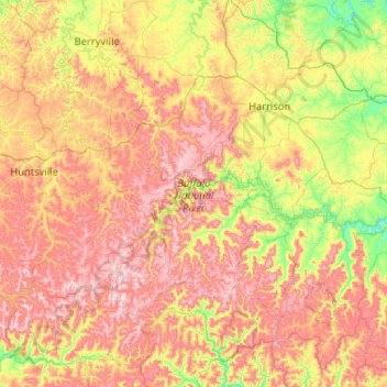
Name: Buffalo National River topographic map, elevation, terrain.
Average elevation: 1,457 ft
Minimum elevation: 617 ft
Maximum elevation: 2,543 ft
Newton County trails, hiking, mountain biking, running and outdoor activities
Make a donation
Gear up for your next adventure:
As an Amazon Associate, this site earns from qualifying purchases at no extra cost to you.
Other topographic maps
Click on a map to view its topography, its elevation and its terrain.
Make a donation
Gear up for your next adventure:
As an Amazon Associate, this site earns from qualifying purchases at no extra cost to you.
Make a donation
Gear up for your next adventure:
As an Amazon Associate, this site earns from qualifying purchases at no extra cost to you.
Make a donation
Gear up for your next adventure:
As an Amazon Associate, this site earns from qualifying purchases at no extra cost to you.
Make a donation
Gear up for your next adventure:
As an Amazon Associate, this site earns from qualifying purchases at no extra cost to you.