Geolocate

Paterson topographic map

Click on the map to display elevation.

About this map

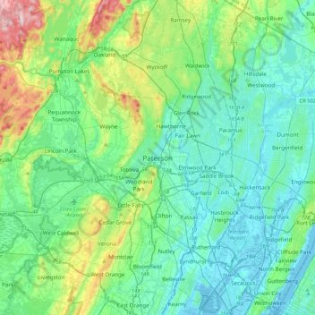
Name: Paterson topographic map, elevation, terrain.

Location: Paterson, Passaic County, New Jersey, 07505, United States (40.75677 -74.33181 41.07677 -74.01181)

Average elevation: 243 ft

Minimum elevation: -10 ft

Maximum elevation: 1,204 ft

Passaic County trails, hiking, mountain biking, running and outdoor activities

Gear up for your next adventure:

🛌Ultralight Sleeping Bags - Compact down bags for cold nights in the wilderness
🧦Merino Wool Socks - Moisture-wicking, blister-preventing socks for long treks
🦶Hiking Gaiters - Keep debris and water out of your boots
🛶Inflatable Kayak - Portable kayak for rivers, lakes, and expeditions
💧Water Filtration Bottles - Safely drink from streams and lakes while exploring

As an Amazon Associate, this site earns from qualifying purchases at no extra cost to you.