
Make a donation
Gear up for your next adventure:
As an Amazon Associate, this site earns from qualifying purchases at no extra cost to you.
Oftering topographic map
Click on the map to display elevation.
Make a donation
Gear up for your next adventure:
As an Amazon Associate, this site earns from qualifying purchases at no extra cost to you.
Oftering
Oftering liegt auf 316 m Höhe im Zentralraum. Die Ausdehnung beträgt von Nord nach Süd 5,5 km, von West nach Ost 3,9 km. Die Gesamtfläche beträgt 13,5 km². Mehr als achtzig Prozent der Fläche werden landwirtschaftlich genutzt, sieben Prozent sind bewaldet.
Make a donation
Gear up for your next adventure:
As an Amazon Associate, this site earns from qualifying purchases at no extra cost to you.
About this map
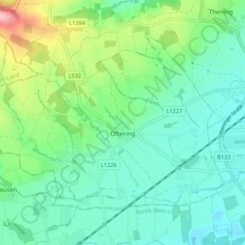
Name: Oftering topographic map, elevation, terrain.
Location: Oftering, Bezirk Linz-Land, Oberösterreich, 4064, Österreich (48.21896 14.09132 48.25382 14.16500)
Average elevation: 1,063 ft
Minimum elevation: 935 ft
Maximum elevation: 1,434 ft
Make a donation
Gear up for your next adventure:
As an Amazon Associate, this site earns from qualifying purchases at no extra cost to you.
Other topographic maps
Click on a map to view its topography, its elevation and its terrain.
Make a donation
Gear up for your next adventure:
As an Amazon Associate, this site earns from qualifying purchases at no extra cost to you.
Make a donation
Gear up for your next adventure:
As an Amazon Associate, this site earns from qualifying purchases at no extra cost to you.
Leimberg
Österreich > Oberösterreich > Bezirk Linz-Land > Niederneukirchen
Average elevation: 1,115 ft
Fischen
Österreich > Oberösterreich > Bezirk Linz-Land > Neuhofen an der Krems
Average elevation: 1,112 ft