
Make a donation
Gear up for your next adventure:
As an Amazon Associate, this site earns from qualifying purchases at no extra cost to you.
Guntersville topographic map
Click on the map to display elevation.
Make a donation
Gear up for your next adventure:
As an Amazon Associate, this site earns from qualifying purchases at no extra cost to you.
About this map
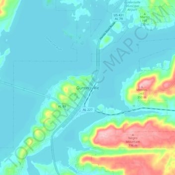
Name: Guntersville topographic map, elevation, terrain.
Location: Guntersville, Marshall County, Alabama, 35976, United States (34.31815 -86.33470 34.39815 -86.25470)
Average elevation: 682 ft
Minimum elevation: 581 ft
Maximum elevation: 1,135 ft
Marshall County trails, hiking, mountain biking, running and outdoor activities
Make a donation
Gear up for your next adventure:
As an Amazon Associate, this site earns from qualifying purchases at no extra cost to you.
Other topographic maps
Click on a map to view its topography, its elevation and its terrain.
Lake Guntersville State Park
United States > Alabama > Marshall County > Guntersville
Average elevation: 794 ft