Geolocate

Trelew topographic map

Click on the map to display elevation.

About this map

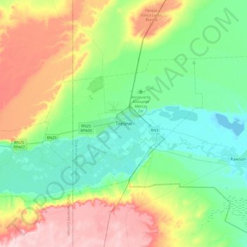
Name: Trelew topographic map, elevation, terrain.

Location: Trelew, Municipio de Trelew, Departamento Rawson, Chubut Province, U9100, Argentina (-43.41312 -65.46944 -43.09312 -65.14944)

Average elevation: 233 ft

Minimum elevation: 0 ft

Maximum elevation: 715 ft

Other topographic maps

Click on a map to view its topography, its elevation and its terrain.

Trevelin

Argentina > Chubut Province

Trevelin has a temperate oceanic climate (Köppen Cfb), but with a rainfall pattern similar to the Mediterranean climate (Köppen Csb). The climate is milder than that of other locations on the Argentine side of Northern Patagonia because of the low altitude and the direct exposure to Pacific winds. This…

Average elevation: 1,322 ft

Desaguadero

Argentina > Chubut Province

Average elevation: 2,569 ft

Gear up for your next adventure:

🧭Pro Hiking Compasses - High-accuracy liquid-filled compasses for topographic orientation
🌐World Map Poster - Decorative world maps with topographic info
📚Navigation Handbooks - Master the art of reading topographic maps and using a compass
🔥Fast-Boil Camping Stoves - Efficient cooking systems for quick trail meals
🗻Climbing Gear Basics - Essential gear for beginner climbers

As an Amazon Associate, this site earns from qualifying purchases at no extra cost to you.