Geolocate

Weskan topographic map

Click on the map to display elevation.

About this map

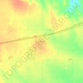
Name: Weskan topographic map, elevation, terrain.

Location: Weskan, Wallace County, Kansas, 67762, United States (38.84667 -101.98434 38.88667 -101.94434)

Average elevation: 3,839 ft

Minimum elevation: 3,747 ft

Maximum elevation: 3,885 ft

Wallace County trails, hiking, mountain biking, running and outdoor activities

Other topographic maps

Click on a map to view its topography, its elevation and its terrain.

Weskan Township

United States > Kansas > Wallace County

Average elevation: 3,796 ft

Gear up for your next adventure:

📱Heavy-Duty Phone Cases - Drop-proof and waterproof protection for outdoor navigation
🔥Fast-Boil Camping Stoves - Efficient cooking systems for quick trail meals
🏫Relief Map Kits - Hands-on tools for teaching landforms and elevation
🧭Outdoor Navigation Book - Learn advanced navigation skills
📌Outdoor GPS Map App - Apps and devices for digital topographic navigation

As an Amazon Associate, this site earns from qualifying purchases at no extra cost to you.