
Make a donation
Gear up for your next adventure:
As an Amazon Associate, this site earns from qualifying purchases at no extra cost to you.
Saint-Julien du Gourg topographic map
Click on the map to display elevation.
Make a donation
Gear up for your next adventure:
As an Amazon Associate, this site earns from qualifying purchases at no extra cost to you.
About this map
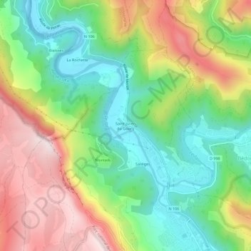
Name: Saint-Julien du Gourg topographic map, elevation, terrain.
Average elevation: 2,441 ft
Minimum elevation: 1,683 ft
Maximum elevation: 3,501 ft
Make a donation
Gear up for your next adventure:
As an Amazon Associate, this site earns from qualifying purchases at no extra cost to you.
Other topographic maps
Click on a map to view its topography, its elevation and its terrain.
Florac
France > Occitanie > Lozère > Florac Trois Rivières
L'aérodrome de Florac-Chanet (code ICAO : LFNO) ou de Florac-Sainte-Enimie de son nom officiel, sur la plaine de Chanet, à proximité de Meyrueis, se trouve sur la partie centrale du causse Méjean, à une altitude d'environ 930 m et à 35 km de Florac. C'est une plateforme à usage restreint, qui accueille…
Average elevation: 2,746 ft