Geolocate

Legok topographic map

Click on the map to display elevation.

About this map

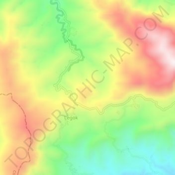
Name: Legok topographic map, elevation, terrain.

Location: Legok, Brebes, Central Java, Indonesia (-7.22991 108.81445 -7.18991 108.85445)

Average elevation: 1,896 ft

Minimum elevation: 876 ft

Maximum elevation: 2,979 ft

Gear up for your next adventure:

🥾Hiking Shoes - Durable and comfortable shoes for trail hiking
🎒Waterproof Dry Bags - Keep your electronics and maps dry inside your pack
📻Weather Alert Radios - Stay informed of storm risks while off-the-grid
🧤Hiking Gloves - Protective gloves for rugged trails
🎒Trekking Poles - Sturdy poles for balance and stability on rough terrain

As an Amazon Associate, this site earns from qualifying purchases at no extra cost to you.