
Thank you for supporting this site ❤️
Make a donation
Make a donation
Gear up for your next adventure:
As an Amazon Associate, this site earns from qualifying purchases at no extra cost to you.
Amazonas topographic map
Click on the map to display elevation.
Thank you for supporting this site ❤️
Make a donation
Make a donation
Gear up for your next adventure:
As an Amazon Associate, this site earns from qualifying purchases at no extra cost to you.
About this map
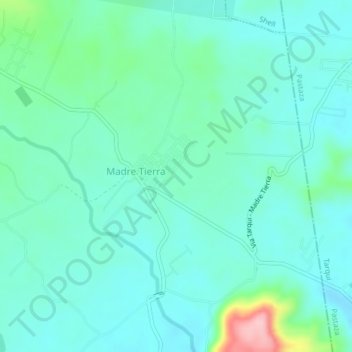
Name: Amazonas topographic map, elevation, terrain.
Location: Amazonas, Madre Tierra, Mera, Pastaza, Ecuador (-1.56318 -78.05096 -1.52318 -78.01096)
Average elevation: 3,094 ft
Minimum elevation: 2,986 ft
Maximum elevation: 3,543 ft
Thank you for supporting this site ❤️
Make a donation
Make a donation
Gear up for your next adventure:
As an Amazon Associate, this site earns from qualifying purchases at no extra cost to you.