Geolocate

Undy topographic map

Click on the map to display elevation.

About this map

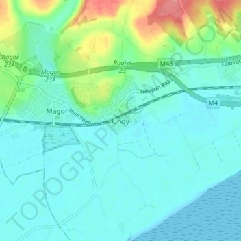
Name: Undy topographic map, elevation, terrain.

Location: Undy, Monmouthshire, Wales, NP26 3FE, United Kingdom (51.55842 -2.83378 51.59842 -2.79378)

Average elevation: 56 ft

Minimum elevation: 0 ft

Maximum elevation: 259 ft

Other topographic maps

Click on a map to view its topography, its elevation and its terrain.

Wye Valley

United Kingdom > Wales > Monmouthshire

Average elevation: 548 ft

Chepstow Castle

United Kingdom > Wales > Monmouthshire > Chepstow

Average elevation: 174 ft

Penallt

United Kingdom > Wales > Monmouthshire

Average elevation: 571 ft

Crucorney

United Kingdom > Wales > Monmouthshire

Average elevation: 974 ft

Blorenge

United Kingdom > Wales > Monmouthshire > Govilon

Average elevation: 1,293 ft

River Monnow

United Kingdom > Wales > Monmouthshire

Average elevation: 564 ft

Llanbadoc

United Kingdom > Wales > Monmouthshire

Average elevation: 256 ft

River Monnow

United Kingdom > Wales > Monmouthshire

Average elevation: 564 ft

Raglan Castle

United Kingdom > Wales > Monmouthshire > Raglan

Average elevation: 194 ft

Gear up for your next adventure:

🧣Merino Neck Gaiters - Multi-functional headwear for wind and sun protection
🚁Photography Drones - Capture stunning aerial views of landforms and topography
🥾Hiking Shoes - Durable and comfortable shoes for trail hiking
🧯Emergency Survival Kit - All‑in‑one survival essentials for the backcountry
🎒Day Hiking Backpack - Lightweight backpack perfect for day trips and outdoor adventures

As an Amazon Associate, this site earns from qualifying purchases at no extra cost to you.