Geolocate

Les Enfrux topographic map

Click on the map to display elevation.

About this map

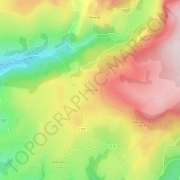
Name: Les Enfrux topographic map, elevation, terrain.

Location: Les Enfrux, Saint-Chély-d'Aubrac, Rodez, Aveyron, Occitanie, France métropolitaine, 12470, France (44.56520 2.93121 44.60520 2.97121)

Average elevation: 3,484 ft

Minimum elevation: 2,628 ft

Maximum elevation: 4,281 ft

Other topographic maps

Click on a map to view its topography, its elevation and its terrain.

La Boralde de Saint-Chély-d'Aubrac

France > Occitanie > Aveyron > Saint-Chély-d'Aubrac

Elle prend source à la frontière communale de Prades-d'Aubrac et Saint-Chély-d'Aubrac, à 1 309 m d'altitude. Elle coule globalement du nord-est vers le sud-ouest. Elle conflue en rive droite du Lot sur la commune de Saint-Côme-d'Olt à 355 m d'altitude

Average elevation: 2,802 ft

Monts d'Aubrac

France > Occitanie > Aveyron > Saint-Chély-d'Aubrac

Average elevation: 3,960 ft

Gear up for your next adventure:

🧤Tactile Hiking Gloves - Keep hands warm while operating GPS and smartphone screens
🔭Telescopic Hiking Pole - Adjustable pole for hiking stability
🔭Compact Binoculars - HD vision for scouting terrain and identifying distant landmarks
🔪Outdoor Multitools - Essential survival tools for gear repair and field use
📡Handheld GPS Device - Reliable handheld GPS for outdoor navigation

As an Amazon Associate, this site earns from qualifying purchases at no extra cost to you.