
Make a donation
Gear up for your next adventure:
As an Amazon Associate, this site earns from qualifying purchases at no extra cost to you.
Soubey topographic map
Click on the map to display elevation.
Make a donation
Gear up for your next adventure:
As an Amazon Associate, this site earns from qualifying purchases at no extra cost to you.
About this map
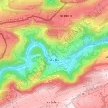
Name: Soubey topographic map, elevation, terrain.
Location: Soubey, District des Franches-Montagnes, Jura, 2887, Suisse (47.29335 7.00768 47.32831 7.08095)
Average elevation: 2,520 ft
Minimum elevation: 1,496 ft
Maximum elevation: 3,327 ft
Make a donation
Gear up for your next adventure:
As an Amazon Associate, this site earns from qualifying purchases at no extra cost to you.
Other topographic maps
Click on a map to view its topography, its elevation and its terrain.
Sur le Rang
Suisse > Jura > District des Franches-Montagnes > Les Pommerats
Average elevation: 2,388 ft
Make a donation
Gear up for your next adventure:
As an Amazon Associate, this site earns from qualifying purchases at no extra cost to you.
Les Barrières
Suisse > Jura > District des Franches-Montagnes > Le Noirmont
Average elevation: 3,143 ft