
Make a donation
Gear up for your next adventure:
As an Amazon Associate, this site earns from qualifying purchases at no extra cost to you.
Saint Kitts topographic map
Click on the map to display elevation.
Make a donation
Gear up for your next adventure:
As an Amazon Associate, this site earns from qualifying purchases at no extra cost to you.
Saint Kitts
The youngest volcanic center is Mt. Liamuiga, 5 km in diameter and rising to an elevation of 1155 m. Its last eruption was 1620 years ago, corresponding with the Steel Dust series of pyroclastic deposits on the western flank. The Mansion Series of pyroclastic deposits and andesite with basalt layers occur on the northern flank, along with mudflows. This volcano has a crater 900 m wide and 244 m deep, plus two distinct parasitic domes consisting primarily of andesite, Brimstone Hill and Sandy Point Hill which is coalesced with Farm Flat. Brimstone Hill is noted for having limestone on its flanks, which was dragged upward with the formation of the dome 44,400 years ago. Mt. Liamuiga partially overlays the Middle Range to the southeast. This Middle Range is another stratovolcano 976 m in height with a small summit crater containing a lake. Next in line is the 900 m South East Range, 1 Myr in age, consisting of four peaks. Ottley's dome and Monkey Hill dome are on the flanks, while the older volcanoes represented by Canada Hills, and Conaree Hills lie past the airport and Basseterre on the southeast flank. The Salt Dome Peninsula contains the oldest volcanic deposits, 2.3–2.77 Myr in age, consisting of at least nine Pelean domes rising up to 319 m in height, which includes Williams Hill and St. Anthony's Peak.
Make a donation
Gear up for your next adventure:
As an Amazon Associate, this site earns from qualifying purchases at no extra cost to you.
About this map
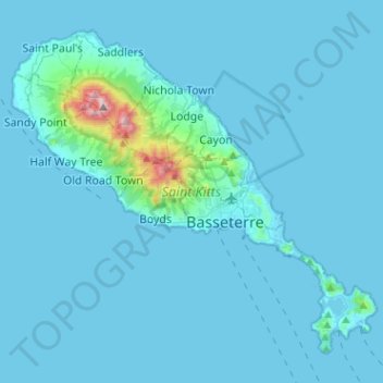
Name: Saint Kitts topographic map, elevation, terrain.
Average elevation: 157 ft
Minimum elevation: -7 ft
Maximum elevation: 3,428 ft
Make a donation
Gear up for your next adventure:
As an Amazon Associate, this site earns from qualifying purchases at no extra cost to you.
Other topographic maps
Click on a map to view its topography, its elevation and its terrain.
Brimstone Hill Fortress National Park
Saint Kitts and Nevis > Brimstone Hill
Average elevation: 240 ft
Make a donation
Gear up for your next adventure:
As an Amazon Associate, this site earns from qualifying purchases at no extra cost to you.
Make a donation
Gear up for your next adventure:
As an Amazon Associate, this site earns from qualifying purchases at no extra cost to you.
Make a donation
Gear up for your next adventure:
As an Amazon Associate, this site earns from qualifying purchases at no extra cost to you.