
Make a donation
Gear up for your next adventure:
As an Amazon Associate, this site earns from qualifying purchases at no extra cost to you.
Figtree topographic map
Click on the map to display elevation.
Make a donation
Gear up for your next adventure:
As an Amazon Associate, this site earns from qualifying purchases at no extra cost to you.
About this map
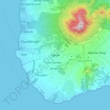
Name: Figtree topographic map, elevation, terrain.
Location: Figtree, Saint John Figtree, Nevis, Saint Kitts and Nevis (17.08954 -62.64246 17.16954 -62.56246)
Average elevation: 449 ft
Minimum elevation: 0 ft
Maximum elevation: 3,127 ft
Make a donation
Gear up for your next adventure:
As an Amazon Associate, this site earns from qualifying purchases at no extra cost to you.
Other topographic maps
Click on a map to view its topography, its elevation and its terrain.
Saint Kitts
The youngest volcanic center is Mt. Liamuiga, 5 km in diameter and rising to an elevation of 1155 m. Its last eruption was 1620 years ago, corresponding with the Steel Dust series of pyroclastic deposits on the western flank. The Mansion Series of pyroclastic deposits and andesite with basalt layers occur on…
Average elevation: 157 ft
Nevis
Seven volcanic centers make up Nevis. These include Round Hill (3.43 Ma), Cades Bay (3.22 Ma), Hurricane Hill (2.7 Ma), Saddle Hill (1.8 Ma), Butlers Mountain (1.1 Ma), Red Cliff and Nevis Peak (0.98 Ma). These are mainly andesite and dacite lava domes, with associated block and ash flows, plus lahars. Nevis…
Average elevation: 302 ft
Brimstone Hill Fortress National Park
Saint Kitts and Nevis > Brimstone Hill
Average elevation: 240 ft
Saint Kitts
The youngest volcanic center is Mt. Liamuiga, 5 kilometres (3.1 mi) in diameter and rising to an elevation of 1,155 metres (3,789 ft). Its last eruption was 1620 years ago, corresponding with the Steel Dust series of pyroclastic deposits on the western flank. The Mansion Series of pyroclastic deposits and…
Average elevation: 157 ft
Make a donation
Gear up for your next adventure:
As an Amazon Associate, this site earns from qualifying purchases at no extra cost to you.
Saint Kitts
The youngest volcanic centre is Mt. Liamuiga, 5 kilometres (3.1 mi) in diameter and rising to an elevation of 1,155 metres (3,789 ft). Its last eruption was 1,620 years ago, corresponding with the Steel Dust series of pyroclastic deposits on the western flank. The Mansion Series of pyroclastic deposits and…
Average elevation: 157 ft
Saint Kitts
The youngest volcanic center is Mt. Liamuiga, 5 kilometres (3.1 mi) in diameter and rising to an elevation of 1,155 metres (3,789 ft). Its last eruption was 1620 years ago, corresponding with the Steel Dust series of pyroclastic deposits on the western flank. The Mansion Series of pyroclastic deposits and…
Average elevation: 157 ft
Nevis
Seven volcanic centers make up Nevis. These include Round Hill (3.43 Ma), Cades Bay (3.22 Ma), Hurricane Hill (2.7 Ma), Saddle Hill (1.8 Ma), Butlers Mountain (1.1 Ma), Red Cliff and Nevis Peak (0.98 Ma). These are mainly andesite and dacite lava domes, with associated block and ash flows, plus lahars. Nevis…
Average elevation: 302 ft
Make a donation
Gear up for your next adventure:
As an Amazon Associate, this site earns from qualifying purchases at no extra cost to you.
Nevis
Seven volcanic centers make up Nevis. These include Round Hill (3.43 Ma), Cades Bay (3.22 Ma), Hurricane Hill (2.7 Ma), Saddle Hill (1.8 Ma), Butlers Mountain (1.1 Ma), Red Cliff and Nevis Peak (0.98 Ma). These are mainly andesite and dacite lava domes, with associated block and ash flows, plus lahars. Nevis…
Average elevation: 302 ft