Geolocate

Hugo topographic map

Click on the map to display elevation.

About this map

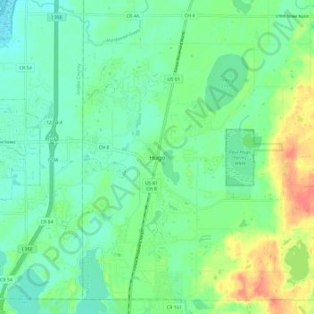
Name: Hugo topographic map, elevation, terrain.

Location: Hugo, Washington County, Minnesota, 55038, United States (45.11997 -93.03327 45.19997 -92.95327)

Average elevation: 935 ft

Minimum elevation: 879 ft

Maximum elevation: 1,050 ft

Washington County trails, hiking, mountain biking, running and outdoor activities

Gear up for your next adventure:

🕶️Glacier Sunglasses - Side shields to protect eyes from high-altitude snow glare
🔭Stargazing Telescopes - Perfect for camping in low-light pollution areas shown on maps
🌧️Backpack Rain Cover - Keep gear dry in wet weather
🔭Telescopic Hiking Pole - Adjustable pole for hiking stability
🧭Map Reading Tools - Tools and kits for map navigation

As an Amazon Associate, this site earns from qualifying purchases at no extra cost to you.