
Thank you for supporting this site ❤️
Make a donation
Make a donation
Gear up for your next adventure:
As an Amazon Associate, this site earns from qualifying purchases at no extra cost to you.
Paintsville topographic map
Click on the map to display elevation.
Thank you for supporting this site ❤️
Make a donation
Make a donation
Gear up for your next adventure:
As an Amazon Associate, this site earns from qualifying purchases at no extra cost to you.
About this map
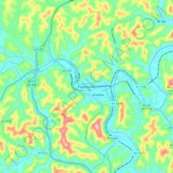
Name: Paintsville topographic map, elevation, terrain.
Location: Paintsville, Johnson County, Kentucky, 41240, United States (37.77454 -82.84711 37.85454 -82.76711)
Average elevation: 797 ft
Minimum elevation: 574 ft
Maximum elevation: 1,309 ft
Johnson County trails, hiking, mountain biking, running and outdoor activities
Thank you for supporting this site ❤️
Make a donation
Make a donation
Gear up for your next adventure:
As an Amazon Associate, this site earns from qualifying purchases at no extra cost to you.