
Thank you for supporting this site ❤️
Make a donation
Make a donation
Gear up for your next adventure:
As an Amazon Associate, this site earns from qualifying purchases at no extra cost to you.
Briviesca topographic map
Click on the map to display elevation.
Thank you for supporting this site ❤️
Make a donation
Make a donation
Gear up for your next adventure:
As an Amazon Associate, this site earns from qualifying purchases at no extra cost to you.
About this map
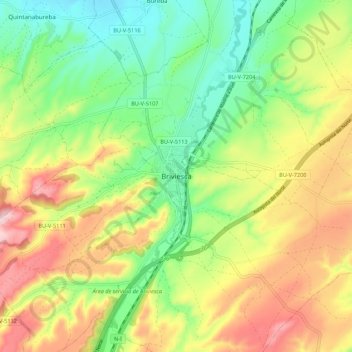
Name: Briviesca topographic map, elevation, terrain.
Location: Briviesca, Burgos, Castilla y León, 09240, España (42.50980 -3.36181 42.58980 -3.28181)
Average elevation: 2,579 ft
Minimum elevation: 2,201 ft
Maximum elevation: 3,087 ft
Thank you for supporting this site ❤️
Make a donation
Make a donation
Gear up for your next adventure:
As an Amazon Associate, this site earns from qualifying purchases at no extra cost to you.