Geolocate

Wheaton topographic map

Click on the map to display elevation.

About this map

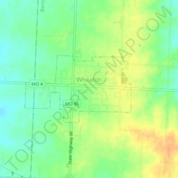
Name: Wheaton topographic map, elevation, terrain.

Location: Wheaton, Barry County, Missouri, United States (36.75630 -94.06839 36.76654 -94.04808)

Average elevation: 1,378 ft

Minimum elevation: 1,325 ft

Maximum elevation: 1,437 ft

Barry County trails, hiking, mountain biking, running and outdoor activities

Other topographic maps

Click on a map to view its topography, its elevation and its terrain.

McDowell

United States > Missouri > Barry County

Average elevation: 1,263 ft

Eagle Rock

United States > Missouri > Barry County

Average elevation: 1,056 ft

Gear up for your next adventure:

🌎3D Topographic Globes - Raised relief globes for a tactile understanding of geography
📶Satellite Messenger - Communication device off‑grid
🎒Waterproof Dry Bags - Keep your electronics and maps dry inside your pack
🏕️Tent Footprint - Protect your tent base from wear
🔥Plasma Lighters - Windproof lighters that work in any weather condition

As an Amazon Associate, this site earns from qualifying purchases at no extra cost to you.