Geolocate

Quarti topographic map

Click on the map to display elevation.

About this map

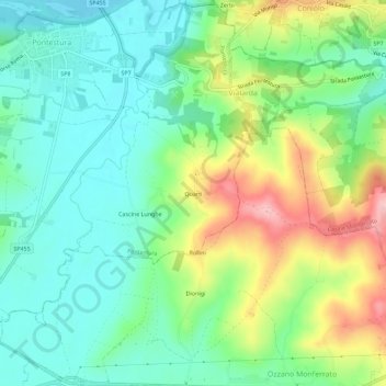
Name: Quarti topographic map, elevation, terrain.

Location: Quarti, Pontestura, Alessandria, Piemonte, 15027, Italia (45.10761 8.33424 45.14761 8.37424)

Average elevation: 584 ft

Minimum elevation: 387 ft

Maximum elevation: 978 ft

Gear up for your next adventure:

🔊Portable Camp Speaker - Music and alerts at camp
👟Trail Running Shoes - Lightweight shoes for trail runners
🛡️Insect Repellent - Protection against bugs during outdoor activities
🎒Gear Packing Cubes - Organize your backpack efficiently
🧭Compass with Lanyard - Easy‑carry compass for navigation

As an Amazon Associate, this site earns from qualifying purchases at no extra cost to you.