Geolocate

Mesquite topographic map

Click on the map to display elevation.

About this map

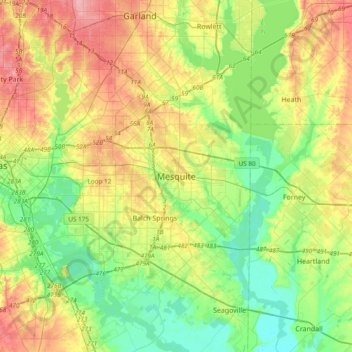
Name: Mesquite topographic map, elevation, terrain.

Location: Mesquite, Dallas County, Texas, 75149, United States (32.60661 -96.75947 32.92661 -96.43947)

Average elevation: 476 ft

Minimum elevation: 344 ft

Maximum elevation: 673 ft

Dallas County trails, hiking, mountain biking, running and outdoor activities

Gear up for your next adventure:

🔦Compact Flashlight - Reliable flashlight for emergencies
📶Vehicle Signal Boosters - Improve reception in rural areas while driving to trailheads
🧤Tactile Hiking Gloves - Keep hands warm while operating GPS and smartphone screens
👟Men's Trail Runners - Lightweight footwear for fast-paced exploration and light hiking
🧭GPS Watch Accessories - Bands and chargers for GPS watches

As an Amazon Associate, this site earns from qualifying purchases at no extra cost to you.