
Make a donation
Gear up for your next adventure:
As an Amazon Associate, this site earns from qualifying purchases at no extra cost to you.
Sana'a topographic map
Click on the map to display elevation.
Make a donation
Gear up for your next adventure:
As an Amazon Associate, this site earns from qualifying purchases at no extra cost to you.
Sana'a
At an elevation of 2,300 metres (7,500 ft),[4] Sanaa is one of the highest capital cities in the world and is next to the Sarawat Mountains of Jabal An-Nabi Shu'ayb and Jabal Tiyal, considered to be the highest mountains in the country and amongst the highest in the region. Sanaa has a population of approximately 3,937,500 (2012), making it Yemen's largest city. As of 2020, the greater Sanaa urban area makes up about 10% of Yemen's total population.[5]
Make a donation
Gear up for your next adventure:
As an Amazon Associate, this site earns from qualifying purchases at no extra cost to you.
About this map
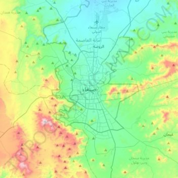
Name: Sana'a topographic map, elevation, terrain.
Average elevation: 8,015 ft
Minimum elevation: 7,126 ft
Maximum elevation: 10,476 ft
Make a donation
Gear up for your next adventure:
As an Amazon Associate, this site earns from qualifying purchases at no extra cost to you.
Other topographic maps
Click on a map to view its topography, its elevation and its terrain.