
Make a donation
Gear up for your next adventure:
As an Amazon Associate, this site earns from qualifying purchases at no extra cost to you.
Cohasset topographic map
Click on the map to display elevation.
Make a donation
Gear up for your next adventure:
As an Amazon Associate, this site earns from qualifying purchases at no extra cost to you.
About this map
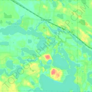
Name: Cohasset topographic map, elevation, terrain.
Location: Cohasset, Itasca County, Minnesota, United States (47.19514 -93.70327 47.28221 -93.57634)
Average elevation: 1,296 ft
Minimum elevation: 1,240 ft
Maximum elevation: 1,470 ft
Itasca County trails, hiking, mountain biking, running and outdoor activities
Make a donation
Gear up for your next adventure:
As an Amazon Associate, this site earns from qualifying purchases at no extra cost to you.
Other topographic maps
Click on a map to view its topography, its elevation and its terrain.
Make a donation
Gear up for your next adventure:
As an Amazon Associate, this site earns from qualifying purchases at no extra cost to you.
Twin Lake Trails Mobile Home Park
United States > Minnesota > Itasca County
Average elevation: 1,375 ft