Geolocate

Corato topographic map

Click on the map to display elevation.

About this map

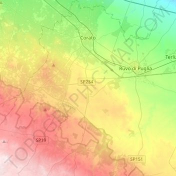
Name: Corato topographic map, elevation, terrain.

Location: Corato, Bari, Apulia, 70033, Italy (40.99245 16.26316 41.19613 16.46839)

Average elevation: 1,017 ft

Minimum elevation: 171 ft

Maximum elevation: 2,110 ft

Other topographic maps

Click on a map to view its topography, its elevation and its terrain.

Altamura

Italy > Apulia > Bari > Altamura

Average elevation: 1,342 ft

Polignano a Mare

Italy > Apulia > Bari

Average elevation: 138 ft

Monte Belvedere

Italy > Apulia > Bari > Altamura

Average elevation: 1,496 ft

Gear up for your next adventure:

🚁Photography Drones - Capture stunning aerial views of landforms and topography
🎒Hydration Pack - Hands‑free water reservoir for long hikes
🌐World Map Poster - Decorative world maps with topographic info
🧷Carabiner Set - Durable clips for gear attachment
Backpacking Tent - Lightweight and durable tent for multi‑day hikes

As an Amazon Associate, this site earns from qualifying purchases at no extra cost to you.