
Make a donation
Gear up for your next adventure:
As an Amazon Associate, this site earns from qualifying purchases at no extra cost to you.
Sira topographic map
Click on the map to display elevation.
Make a donation
Gear up for your next adventure:
As an Amazon Associate, this site earns from qualifying purchases at no extra cost to you.
Sira
Sira is located at 13°45′N 76°55′E / 13.75°N 76.91°E / 13.75; 76.91. It has an average elevation of 662 metres (2171 feet).
Make a donation
Gear up for your next adventure:
As an Amazon Associate, this site earns from qualifying purchases at no extra cost to you.
About this map
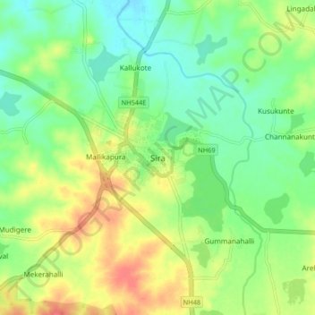
Name: Sira topographic map, elevation, terrain.
Location: Sira, Sira taluk, Tumakuru, Karnataka, 572137, India (13.70095 76.86574 13.78095 76.94574)
Average elevation: 2,149 ft
Minimum elevation: 2,073 ft
Maximum elevation: 2,254 ft
Make a donation
Gear up for your next adventure:
As an Amazon Associate, this site earns from qualifying purchases at no extra cost to you.