Geolocate

Tubod topographic map

Click on the map to display elevation.

About this map

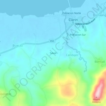
Name: Tubod topographic map, elevation, terrain.

Location: Tubod, Candajec, Bohol, Central Visayas, 3629, Philippines (9.93000 123.99667 9.97000 124.03667)

Average elevation: 161 ft

Minimum elevation: -26 ft

Maximum elevation: 935 ft

Gear up for your next adventure:

🛌Ultralight Sleeping Bags - Compact down bags for cold nights in the wilderness
🍳Camping Cook Set - Complete cookware for outdoor meals
🔪Outdoor Multitools - Essential survival tools for gear repair and field use
📌Outdoor GPS Map App - Apps and devices for digital topographic navigation
📷Action Cameras - Rugged cameras to document your journeys across rugged terrain

As an Amazon Associate, this site earns from qualifying purchases at no extra cost to you.