
Make a donation
Gear up for your next adventure:
As an Amazon Associate, this site earns from qualifying purchases at no extra cost to you.
Gampola topographic map
Click on the map to display elevation.
Make a donation
Gear up for your next adventure:
As an Amazon Associate, this site earns from qualifying purchases at no extra cost to you.
Gampola
Gampola, or so called Gangasiripura because of the Mahaweli (Mahaweli Ganga) flowing by its side, is a town which is located at an altitude of 300–500 m (980–1,640 ft), situated in a valley surrounded by hills and located near to Kandy. Geologically the region belongs to the Highland Complex of Sri Lanka and major rock formation is Precambrian charnockite gneiss with strips of quartz and biotite gneiss here and there. Soil profile of the region could identify as Red Yellow Podzolic soils and Mountain Regosols. Mean annual rainfall is in between 3,000 and 3,500 mm (120 and 140 in) and mean annual temperature is in between 20 and 25 °C (68 and 77 °F). Due to the geomorphology of the Gampola and its vicinity, which characterised by steep hills stand from plain, it was declared as a landslide prone area. However, with its flat terrain with being a catchment area of River Mahaweli, our region has become highly used in agricultural purposes both in traditional (paddy, chena, home gardens) and industrial plantations (majorly tea). Tea, natural forests, mixed home gardens, steeply dissected hilly and rolling, soil profile with the prominent A1 horizon and lithosol soils can be considered as its unique ecological background. Administratively, Gampola is an urban council belongs to the Kandy district of Central Province. In traditional administration region system, it once belonged to the Maya rata before the 13th cent. AD and in Kandy period to the Ganga Pahala Koralaya of Uda Palatha of Kandy district.
Make a donation
Gear up for your next adventure:
As an Amazon Associate, this site earns from qualifying purchases at no extra cost to you.
About this map
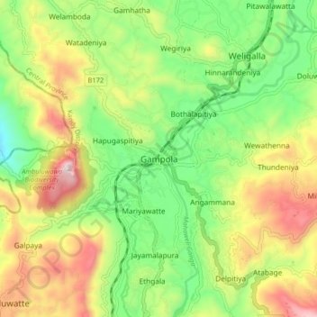
Name: Gampola topographic map, elevation, terrain.
Location: Gampola, Kandy District, Central Province, 20500, Sri Lanka (7.12365 80.53027 7.20365 80.61027)
Average elevation: 1,982 ft
Minimum elevation: 932 ft
Maximum elevation: 3,468 ft
Make a donation
Gear up for your next adventure:
As an Amazon Associate, this site earns from qualifying purchases at no extra cost to you.
Other topographic maps
Click on a map to view its topography, its elevation and its terrain.
Horton Plains National Park
Horton Plains National Park (Sinhala: හෝර්ටන් තැන්න ජාතික උද්යානය, romanized: Hortan Thanna Jathika Udyanaya) is a national park in the central highlands of Sri Lanka that was designated in 1988. It is located at an elevation of 2,100–2,300 m (6,900–7,500…
Average elevation: 6,594 ft
Make a donation
Gear up for your next adventure:
As an Amazon Associate, this site earns from qualifying purchases at no extra cost to you.
Horton Plains National Park
Horton Plains National Park (Sinhala: හෝර්ටන් තැන්න ජාතික උද්යානය, romanized: Hortan Thanna Jathika Udyanaya) is a national park in the central highlands of Sri Lanka that was designated in 1988. It covers an area of 31km² and borders Thotupalakanda Nature…
Average elevation: 6,594 ft
Make a donation
Gear up for your next adventure:
As an Amazon Associate, this site earns from qualifying purchases at no extra cost to you.