Geolocate

Basildon topographic map

Click on the map to display elevation.

About this map

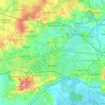
Name: Basildon topographic map, elevation, terrain.

Location: Basildon, Essex, England, United Kingdom (51.52982 0.37510 51.65124 0.56877)

Average elevation: 112 ft

Minimum elevation: -10 ft

Maximum elevation: 397 ft

Other topographic maps

Click on a map to view its topography, its elevation and its terrain.

Bulphan

United Kingdom > England > Essex

Average elevation: 33 ft

Saffron Walden

United Kingdom > England > Essex > Uttlesford

Average elevation: 289 ft

Winter Gardens

United Kingdom > England > Essex > Castle Point

Average elevation: 30 ft

Ramsden Heath

United Kingdom > England > Essex > Chelmsford

Average elevation: 190 ft

Wickford

United Kingdom > England > Essex

Average elevation: 89 ft

Little Walden

United Kingdom > England > Essex > Uttlesford

Average elevation: 308 ft

Hadleigh

United Kingdom > England > Essex > Castle Point

Average elevation: 95 ft

Stroud Green

United Kingdom > England > Essex > Rochford

Average elevation: 72 ft

Wivenhoe Woods

United Kingdom > England > Essex > Colchester > Wivenhoe > Rowhedge

Average elevation: 59 ft

Parkeston

United Kingdom > England > Essex > Parkeston

Average elevation: 16 ft

Dovercourt

United Kingdom > England > Essex > Tendring

Average elevation: 13 ft

Leigh Beck

United Kingdom > England > Essex > Castle Point

Average elevation: 3 ft

Mill End

United Kingdom > England > Essex > Uttlesford > Molehill Green

Average elevation: 331 ft

Gear up for your next adventure:

🥘Titanium Cookware - Durable, featherlight pots and pans for backpacking
🏫Relief Map Kits - Hands-on tools for teaching landforms and elevation
🧭GPS Watch Accessories - Bands and chargers for GPS watches
🔊Portable Camp Speaker - Music and alerts at camp
🔋Rechargeable Batteries - Power up your outdoor devices

As an Amazon Associate, this site earns from qualifying purchases at no extra cost to you.